A BOG is a wetland that’s acidic
A FEN is a wetland that’s alkaline
A SWAMP is a wetland that’s vegetation consists of trees or other woody plants
A MARSH is a wetland with other forms of vegetation. If the marsh is seasonal or located in the Adirondacks, it’s a VLEI.
A MOOR is an extensive waste covered with patches of heath, having a poor, light soil, that’s sometimes marshy.
And here’s some more in-depth stuff from the USGS.
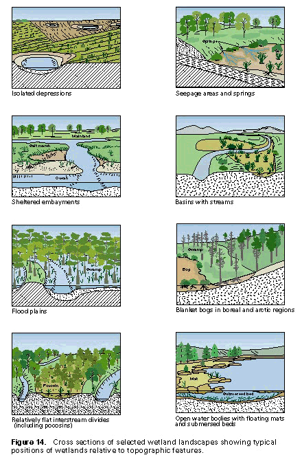
“Wetland” is a generic term for all the different kinds of wet habitats–implying that it is land that is wet for some period of time, but not necessarily permanently wet. Wetlands have numerous definitions and classifications in the United States as a result of their diversity, the need for their inventory, and the regulation of their uses. This article provides an overview of wetland definitions and classification systems of major wetland types in the United States. It also introduces the U.S. Fish and Wildlife Service (FWS) classification system (Cowardin and others, 1979) that is used throughout this volume.Wetlands typically occur in topographic settings where surface water collects and (or) ground water discharges, making the area wet for extended periods of time. Examples of some of these topographic settings, and some common names for wetland types associated with them are:
|
Cross sections of some typical wetland landscapes and the position of the wetland relative to specific topographic features are shown in the chart. All areas considered to be wetlands must have enough water at some time during the year to stress plants and animals that are not adapted to life in water or saturated soils. A variety of wetland plant communities and soil types have developed in the United States because of regional differences in hydrologic regimes, climate, soil-forming processes, and geologic settings. Consequently, many terms, such as “marsh,” “bog,” “fen,” “swamp,” “pocosin,” “pothole,” “playa,” “salina,” “vernal pool,” “bottom-land hardwood swamp,” “river bottom,” “lowland,” and others are applied to different types of wetlands across the country. |
WETLAND DEFINITIONS |
||
Wetlands have been defined for specific purposes, such as research studies, general habitat classification, natural resource inventories, and environmental regulations. Before the beginning of wetland-protection laws in the 1960’s, wetlands were Broadly defined by scientists working in specialized fields (Lefor and Kennard, 1977). A botanist’s definition would emphasize plants; a soil scientist would focus on soil properties; and a hydrologist’s definition would emphasize fluctuations of the water table.
Nonregulatory DefinitionThe FWS developed a nonregulatory, technical definition that could have several uses, ranging from wetland protection to scientific investigations. This definition emphasizes three important attributes of wetlands: (1) hydrology–the degree of flooding or soil saturation; (2) vegetation–plants adapted to grow in water or in a soil or substrate that is occasionally oxygen deficient due to saturation (hydrophytes); and (3) soils–those saturated long enough during the growing season to produce oxygen-deficient conditions in the upper part of the soil, which commonly includes the major part of the root zone of plants (hydric soils) (Cowardin and others, 1979; Tiner, 1991). To supplement this definition and to help identify wetlands in the United States, the FWS prepared a list of wetland plants (Reed, 1988). In addition, the Soil Conservation Service 1 developed a list of hydric soils (U.S. Soil Conservation Service, 1991).On the basis of plant and soil conditions, wetlands typically fall into one of three categories: (1) areas with hydrophytes and hydric soils (marshes, swamps, and bogs); (2) areas without soils but with hydrophytes (aquatic beds and seaweed-covered rocky shores); and (3) areas without soil and without hydrophytes (gravel beaches and tidal flats) that are periodically flooded. The FWS definition generally does not include permanent deep-water areas as wetlands. However, permanent shallow waters that commonly support aquatic beds and emergent plants (erect, rooted, nonwoody plants that are mostly above water) are classified as wetlands. |
Regulatory Definitions as Compared to Nonregulatory DefinitionsIn the 1960’s and 1970’s, State and Federal environmental laws gave some protection to wetlands. On the basis of different interests to be protected, however, each governing body developed a different definition of wetlands. Examples of some of these definitions are given in table 2. Only wet soils vegetated with hydrophytes are considered as wetlands by the three Federal agencies involved with regulation–the SCS, the U.S. Environmental Protection Agency (EPA), and the U.S. Army Corps of Engineers (Corps). The FWS uses a nonregulatory definition that is Broader and includes aquatic beds in shallow freshwater and naturally nonvegetated areas. In the context of vegetated wetlands, all four agency definitions are conceptually the same in that they include hydrology, vegetation, and soils.Most States have developed regulatory definitions to protect certain wetlands from exploitation. Therefore, State definitions are much Broader than any of the Federal definitions. The State definitions tend to emphasize the presence of certain plants for identification purposes (table 2). However, the States did not produce a comprehensive list of “wetland plant species,” making it difficult to use vegetation consistently to identify the limits of wetlands (Tiner, 1989 and 1993a). |
|