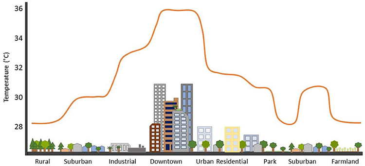
Think about your own neck of the woods. If you’re over fifty you probably remember the nearest airport being much smaller. Many temperature and rain monitoring sets were placed out at the edge of an air field. As the years progressed more concrete was laid for runways and access roads and it became a very different environment – in fact it became a heat island. (Developed areas that are significantly hotter than surrounding rural areas due to the replacement of natural, vegetated areas with impervious surfaces like pavement and buildings, which absorb solar radiation).
Think of weather stations in schools – once out in the sports fields, now in parking lots and close to new buildings. This all skews the data. Satellite measuring has only been available since around 1979 – measurements before that are almost always going to be lower.
Look at this. The whole of Africa being lumped in with high-density city data. It’s wrong. But the eco-cultists don’t care. They use this misinformation to push their anti-human agenda and enforce all manner of debilitating rules and regulations.
They won’t rest until most of us are dead. They want us to starve, freeze, and live in easily controllable urban compounds so they can “re-wild” the planet. They are insane and dangerous.
More people live in Brazzaville/Kinshasa than New York City, and their thermometers are located next to airport runways. This UHI contaminated thermometer data corrupts all of @NOAA's data from central Africa.#ClimateScam https://t.co/7E71SDdZY3 pic.twitter.com/1ebvTYwLLk
— Tony Heller (@TonyClimate) December 28, 2023